VFR Navigation
Navigation Requirements
Pilots of VFR aircraft must navigate with visual reference to the ground or water, or comply with the requirements of IFR flight. Equipment like GPSes and ground-based navaids can be used to supplement visual navigation.
A visual fix (positively identifying your position) must be obtained every 30 minutes.
Pilots may plan via any waypoint (including RNAV waypoints), track via instrument approaches, and conduct SIDs and STARs, provided they remain in VMC and comply with the rules of VFR flight.
Creating a Navlog
After finalising your route, a navlog should be created listing:
- each tracking point
- distance and track between each point
- altitude you wish to fly each leg at
- estimated groundspeed for each leg based on the forecast wind
- estimated time each leg will take
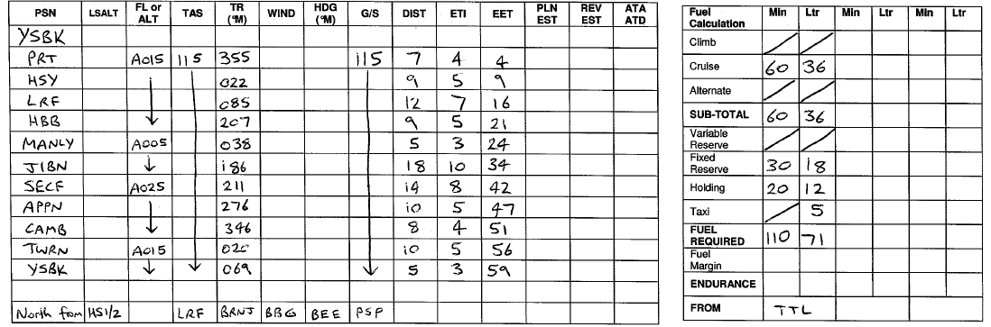
Note
In the sample navlog above, the wind and heading fields have not yet been filled out. It is best practice to obtain a forecast wind for the intended flight and calculate the heading required to maintain a given track made good, corrected for wind. These should be filled out in the appropriate fields.
Wind Correction
VFR navigation is built on the principle of flying a particular heading for a given amount of time, and arriving over the expected next position. The desired track to be flown must be corrected for wind to ensure that the aircraft does not drift off course. Additionally, strong headwinds or tailwinds will alter the time taken to fly each leg, and therefore the fuel required.
Wind correction can be performed using a manual flight computer or a variety of online tools.
Tip
Search online for 'wind calculator' to access resources which will assist in determing the required wind correction.
Fuel Planning
Once your desired route has been chosen and your planned TAS has been corrected for wind, you can determine the total time required to complete each leg. This information can be used to determine the amount of fuel required to complete the flight.
See flight planning for detailed notes on how to create an accurate fuel plan.
Map Reading
All maps and charts are available for free on the Airservices Australia website. Pilots should use a combination of VTCs (in terminal areas), VNCs (in surrounding areas) and WACs (outside of VNC coverage) to plot their desired track and navigate enroute. Alternatively, real world EFB apps or flight simulation products like Little Navmap and Navigraph can be used to provide moving map functions to simulated flights.
During your route planning, you should select large, obvious landmarks as your tracking points. As you approach each tracking point, look for lead-in features which will aid in early recognition of each landmark.
Map-to-Ground Technique
As you pass overhead each tracking point, note the time on your navlog and calculate your ETA for your next point (based on your calculated leg time). Turn to your calculated heading (to correct for any wind and make good the desired track) and as you get close to the next tracking point, start looking for any identified lead-in features.
You should navigate with primary reference to your map or chart, searching for large, easily identifiable features on the ground by looking in the direction where you expect to the find them. Navigate from 'map-to-ground' rather than by looking outside, finding a large feature, and trying to find it on the map.
Your current position can be determined by measuring the direction from your aircraft to various identifiable landmarks and triangulating their intersection on the map. Using this method, you can calculate whether you are off track (due to actual winds differing from those forecast, or through aircraft manipulation/navigation errors), and make corrections as required.
The same method can be used to determine whether your calculated leg times are accurate and apply corrections to future legs, estimating whether your current fuel state is sufficient to complete the flight.
Lost Procedure
If you find yourself unfamiliar with your surroundings and are no longer confident in your position, a lost procedure should be adopted.
Unlike during normal navigation, scan your surroundings and read from 'ground-to-map', locating each landmark on the map after identifying it outside. By measuring the direction from your aircraft to each landmark, you can triangulate your position on the map.
ATC can use their surveillance equipment (within surveillance coverage) to provide you with position information. If you become lost, request assistance from the most appropriate controller, who will attempt to identify you and provide you with tracking assistance.
Note
If operating in CTA, you must notify ATC as soon as you become aware that you are off track, or if you are no longer confident in your position.